PIX4Dsurvey 1.39: share to PIX4Dcloud and profile tools!
PIX4Dsurvey provides advanced automation capabilities and tools for vectorization and export to CAD and GIS. The last release of the year for PIX4Dsurvey brings improved integration between Pix4D products: sharing to PIX4Dcloud with the click of a button! In addition, the profiles and sections tool now has an extensive set of functions to create profiles and sections with modified settings as well as visualization that helps you vectorize with more accuracy and incredible ease. Lastly, by leveraging the accuracy provided by the profile view, you are able now to offset a polyline, maintaining the curvature and distance of the initial polyline.
Easy integration with PIX4Dcloud!
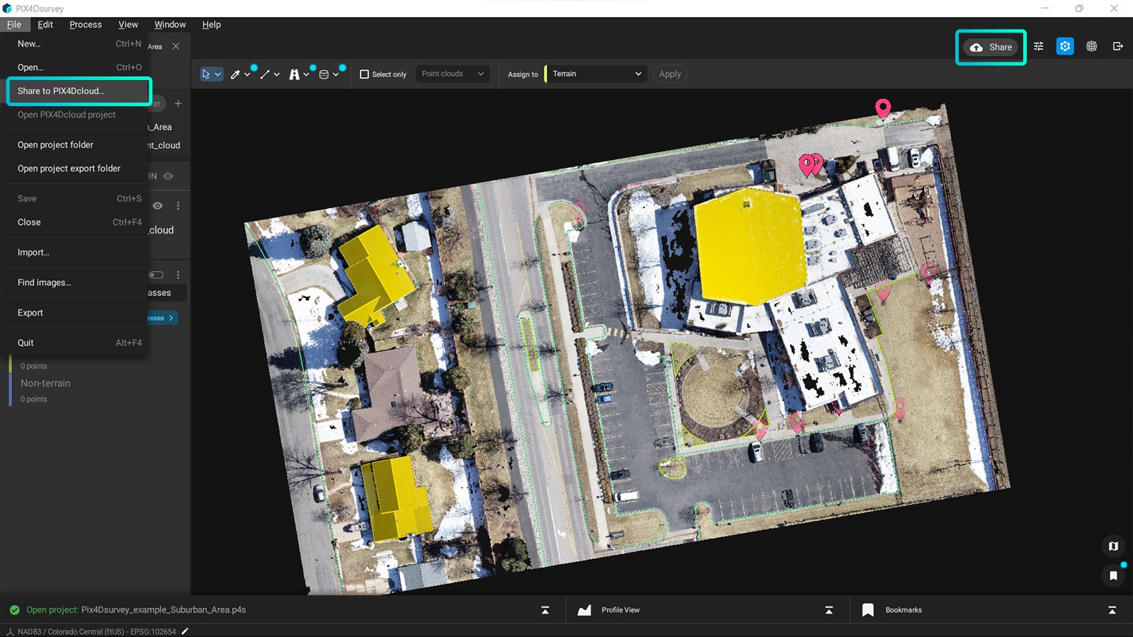
The integration with PIX4Dcloud has been requested by many Pix4D users. We are very happy to announce that you can now share your project from PIX4Dsurvey on PIX4Dcloud with just a web link. Share your point cloud, vector layers, and volume layers with colleagues and clients, choose whether you provide viewing or editing rights to enhance collaboration and speed up your job using our secure cloud solution. Access the Share to PIX4Dcloud dialog window either through the file menu or with the use of the “Share” button, for quick and smooth integration with PIX4Dcloud. All layers will be stored in PIX4Dcloud with shareable URL links. Learn more about the requirements and capabilities of the sharing to PIX4Dcloud and the step-by-step process with the help of our support article. (Included in your PIX4Dsurvey license are 12 projects for perpetual and yearly licenses and 1 project for monthly licenses and trials - make sure you try it out!)

Better profiles and sections!
In the previous stable release of PIX4Dsurvey, you could draw the profile in an area of your interest and visualize point clouds and vectors in a section along this specific profile, with the ability to show its cross-section in its own viewport. In the 1.39 release, the profile workflow has drastically evolved and can now provide more valuable data on the elevation differences of an area.
The intuitive user interface of PIX4Dsurvey ensures that you can easily get all the information from the profile tool. The profile appears as a blue box in the 3D view and also in its projection on the section. With this, you can easily link the 3D information to the profile view. The section also contains a reference grid that re-scales when zooming in and whose size is always displayed in the bottom right corner. As a result, you have a constant estimation of the scale while vectorizing your point cloud, helping you to vectorize with the desired accuracy and detail. You can also modify the visualization settings of the profile according to the needs of your project. Point cloud cleanup in the profile view becomes easier than ever before, thanks to selection sets that are clipped by the profile view. Learn more about this in the dedicated support article.
In addition, you can now define the interval between the steps as well as the orientation and move the profile box along the area of interest. The profile box will create different cuts of the point cloud and will move horizontally (for straight profiles) or along a polyline (for perpendicular profiles).
The straight profile is a profile where the different steps are parallel to each other.

The perpendicular profile allows the section to move along a polyline by keeping the profile perpendicular to the polyline, no matter how long or sinuous.

Surveying linear objects like roads or railways is a very challenging task due to many factors, such as the geometry, the size, and moving traffic. PIXDsurvey has an extensive toolkit of features and capabilities that makes it easy to vectorize roads including manhole detection, road marking, curb extraction, and much more. Many times, surveying a road means laborious field work that requires measurements of points with specific intervals that describe the geometry of the road in order to vectorize it in CAD. The brand new features of profiles and sections of PIX4Dsurvey will allow you to work effectively with linear objects in point clouds (created with photogrammetry, laser scanners, LiDAR or other third-party tool in .las or .laz format) as the sections makes the vectorization of edges and elevation differences easier and more accurate.
Try the new functionalities and workflows of PIX4Dsurvey for yourself by downloading the latest version now! Learn more on our support site, from our online workshops, and watch our free webinar on combining aerial and terrestrial mapping. Visit our blog and see how other professionals used PIX4Dsurvey to generate incredible results and if you are a current PIX4Dmapper user, make sure to not miss our current special offer!


